To Track Fay via radar imagery, you can click on this Interactive Radar (Click Here) and zoom in to street level, loop and navigate anywhere in the state of Florida, The South or the entire nation for that matter.

5 Day Rainfall Forecast 0825 00Z to 0830 00z
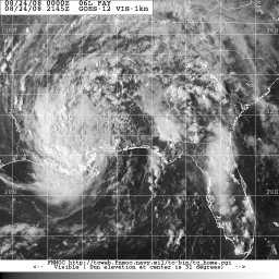
Tropical Storm Fay is now Tropical Depression Fay and will soon be just a

7 Day Rainfall estimate 0817 8am to 0824 8am
tropical low. The center of circulation has broadened nicely. Areas that got too much rain continue to get passing rain and t’storms. As you can tell from the 7 Day rain accumulation through Sunday morning at right, areas like North Georgia that need the rain are getting some. The moisture should stay bottled up in the South for a time as a frontal boundary pushes down. By midweek, the system should lift north enough that some shower activity may move into the Ohio Valley. But most of the rain will slip off to the east and bring the rain that they need in Eastern Tennessee and North Georgia, as you can tell from the HPC 5 day rain forecast at left. Except for the stories of woe from the heavy rain, Fay is pretty much done with and the National Hurricane Center has handed off Fay to the Hydrometeorological Prediction Center (HPC) and is now concentrating its attention on other items of interest.


Invest 94L Spaghetti Model 0824 18Z
Invest 95L is still out there and looks decent on satellite imagery. As I said

Invest 94L Spaghetti Intensity Graph 0824 18Z
before, all indications are that it will be of interest to mariners though I saw one model that wants to swing it close to the east coast, but still offshore. Now, Invest 94L is looking so interesting that the National Hurricane Center has a couple of flights planned to investigate on Monday. If the conditions remain worthwhile, the Hurricane Reconassaince folks will be out and about to see if a depression has formed. Satellite imagery looks to show something trying to come together. The Invest 94L Spaghetti model indicates a wide variance of opinion with some models taking it up toward Florida while others wanting to take it to South America. The truth is probably somewhere in between which is why this guy will need to be monitored. Should it get going good and even sniff the Gulf of Mexico, we’ll all pay for it at the pump whether or not it even gets close to any drilling operations. The spaghetti intensity graph remains muddled depending whether or not your model of choice runs it into land or even develops it any further.
Posted in Bob Symon, Louisville Forecast, News, Opinion, Science, Tropical Cyclones, Tropics, Weather | Tagged: 5 Day rain forecast through Friday evening 8/29, 7 Day SE rain totals, Fay Satellite, Hydrometeorological Prediction Center, Invest 94L Spaghetti intensity graph, Invest 94L Spaghetti Model, Tropical Storm Fay Radar Loop, US Interactive Radar | Leave a Comment »

24-Hour Rain to 8AM Sunday
To Track Fay via radar imagery, you can click on this Interactive Radar (Click Here) and zoom in to street level, loop and navigate anywhere in the state of Florida or the entire nation.
A couple of things of interest. The National Hurricane Center has lost interest and passed on the tracking of Fay to the Hydrometeorological Prediction Center. The HPC track goes into Louisiana or Mississippi and by Thursday actually takes it to near Lexington, KY. So, I stand by my previous assertion that rain will make its way into the Louisville Metro Area by the end of the week.
Note some of the rain totals. Tallahassee was listed at over 19 inches and I bet that it continues for part of Sunday.

0824 Invest 94L Spaghetti Model 12Z
The NHC is taking a harder look at Invest 94L that you and I have been eyeballing

0824 Invest 94L Spaghetti Intensity Graph
for a week. For the first time, they have inserted the word “depression” into the discussion. You will find the Invest 94L Spaghetti Model and the Invest 94L Spaghetti Intensity Graph. Do not take them as gospel. However, the trend this time around is for not as many models making it a hurricane as the data suggests many models advertise interaction with land masses. Invest 95L remains out there. It still appears to be more of a concern for mariners…unless you are a Seattle Mariner and then your concern is the American League West basement.
PUBLIC ADVISORY NUMBER 36 FOR TROPICAL DEPRESSION FAY NWS HYDROMETEOROLOGICAL PREDICTION CENTER CAMP SPRINGS MD AL062008 1000 AM CDT SUN AUG 24 2008 …HEAVY RAIN WILL LINGER ACROSS THE SOUTH DESPITE A WEAKENING FAY… FLOOD WARNINGS ARE IN EFFECT FOR SOUTHERN ALABAMA…SOUTHWESTERN GEORGIA…AND ACROSS THE FLORIDA PANHANDLE INTO PORTIONS OF THE FLORIDA PENINSULA. FLASH FLOOD WATCHES ARE IN EFFECT THROUGH THIS EVENING FOR THE FLORIDA PANHANDLE…SOUTHWESTERN GEORGIA…SOUTHERN ALABAMA…MUCH OF MISSISSIPPI AND INTO PARTS OF EASTERN LOUISIANA AND EXTREME SOUTHEASTERN ARKANSAS. AT 1000 AM CDT…15Z…THE CENTER OF TROPICAL DEPRESSION FAY WAS LOCATED NEAR LATITUDE 32.0 NORTH…LONGITUDE 89.0 WEST…OR ABOUT 70 MILES..113 KM…EAST-SOUTHEAST OF JACKSON MISSISSIPPI AND 25 MILES…40 KM… SOUTH-SOUTHWEST OF MERIDIAN MISSISSIPPI. THE DEPRESSION IS MOVING TOWARD THE WEST NEAR 10 MPH. A GENERAL WEST-SOUTHWEST MOTION WITH LITTLE CHANGE IN FORWARD SPEED IS EXPECTED SUNDAY…BUT FAY COULD BECOME NEARLY STATIONARY OR STALL ON MONDAY. THE FORECAST TRACK WILL TAKE FAY INTO SOUTHERN MISSISSIPPI SUNDAY AFTERNOON AND FAY WILL BE LOCATED OVER EASTERN LOUISIANA OR SOUTHERN MISSISSIPPI ON MONDAY. MAXIMUM SUSTAINED WINDS ARE NEAR 30 MPH..48 KM/HR…WITH HIGHER GUSTS. GRADUAL WEAKENING IS FORECAST DURING THE NEXT COUPLE OF DAYS. THE MINIMUM CENTRAL PRESSURE IS 1001 MB…29.56 INCHES. SELECTED STORM TOTAL RAINFALL AMOUNTS IN INCHES THROUGH 700 AM CDT …ALABAMA… VALLEY 0.4 NNW 7.12 CAMDEN 1.0 NNE 6.83 CLIO 0.2 SSW 6.38 ELFAULA 1.0 SSE 6.26 TROY 1.5 ESE 6.21 WETUMPKA 5.0 SE 6.14 CLOPTON 0.1 SW 5.96 LADONIA 13.2 SSW 5.90 ALEXANDER CITY 10.0 SW 5.77 PINE HILL 3.6 WSW 5.76 SYLACAUGS 9.2 S 5.65 TROY 5.60 OZARK 5.36 DOTHAN 4.17 AUBURN 4.04 MONTGOMERY 3.81 BIRMINGHAM 3.28 ALABASTER 2.77 ANNISTON 2.14 EVERGREEN 2.14 TUSCALOOSA 2.10 …FLORIDA… MELBOURNE BEACH 3.9 SSE 25.28 COCOA BEACH 24.38 CAPE CANAVERAL 22.83 DELTONA 22.69 SATELLITE BEACH 22.40 PALM SHORES 1.4 W 21.44 DELTONA 2.9 SE 20.94 MELBOURNE 7.0 NW 20.57 ORANGE CITY 19.81 HILLIARD 5.4 NW 19.70 TALLAHASSEE 5.7 SE 19.17 MALABAR 2.9 NNW 19.00 WACISSA 1.1 SW 18.09 SANFORD 0.4 ENE 18.03 LAKEWOOD PARK 0.5 SW 17.90 DE LAND 4.5 NW 17.20 COCOA 5.8 NW 16.77 MICCO 4.5 NW 16.26 LONGWOOD 2.3 WNW 15.70 EUSTIS 1.2 SE 15.56 HOBE SOUND 3.9 NW 15.01 SANFORD 14.97 PALM BAY 14.89 NORTH MAPLES 7.3 E 14.42 JACKSONVILLE 7.3 SW 14.40 DE LEON SPRINGS 0.4 SE 14.23 FORT PIERCE 11.58 JACKSONVILLE 11.58 …GEORGIA… VALDOSTA (MOODY AFB) 8.54 ALBANY 4.92 SAVANNAH (HUNTER AAF) 4.41 ALMA 3.99 FORT BENNING 3.66 SAVANNAH 3.16 COLUMBUS 3.15 BRUNSWICK 2.89 MACON 1.49 …LOUISIANA… LAFAYETTE 1.31 NEW ORLEANS (NEW) 1.24 BOOTHVILLE 1.16 …MISSISSIPPI… JACKSON (WFO) 3.92 MERIDIAN (NAS/MCCAIN) 3.74 COLUMBUS (AFB) 3.39 MERIDIAN 2.54 GREENWOOD 2.43 JACKSON 2.40 NATCHEZ 2.15 VICKSBURG 1.37 TUPELO 1.31 …SOUTH CAROLINA… BEAUFORT 5.34 CHARLESTON 2.67 TROPICAL DEPRESSION FAY IS EXPECTED TO PRODUCE RAINFALL ACCUMULATIONS OF 3 TO 6 INCHES OVER PORTIONS OF MISSISSIPPI…ALABAMA…EASTERN LOUISIANA…WESTERN GEORGIA AND THE FLORIDA PANHANDLE THROUGH TUESDAY MORNING….WITH ISOLATED MAXIMUM AMOUNTS OF 10 INCHES POSSIBLE. LIGHTER RAINFALL ACCUMULATIONS OF 1 TO 2 INCHES ARE POSSIBLE ACROSS SOUTHERN TENNESSEE… EASTERN GEORGIA… EASTERN ARKANSAS AND THE FLORIDA PENINSULA. SEVERE THUNDERSTORMS AND ISOLATED TORNADOES ARE POSSIBLE TODAY ACROSS THE FLORIDA PANHANDLE AND NORTHERN FLORIDA PENINSULA INTO GEORGIA AND ALABAMA. REPEATING THE 1000 AM CDT POSITION…32.0 N…89.0 W. MOVEMENT TOWARD…WEST NEAR 10 MPH. MAXIMUM SUSTAINED WINDS…30 MPH. MINIMUM CENTRAL PRESSURE…1001 MB. THE NEXT ADVISORY WILL BE ISSUED BY THE HYDROMETEOROLOGICAL PREDICTION CENTER AT 400 PM CDT. PLEASE REFER TO YOUR LOCAL NATIONAL WEATHER SERVICE OFFICE OR WEATHER.GOV FOR FURTHER INFORMATION ON THIS STORM. MUSHER FORECAST POSITIONS INITIAL 24/1500Z 31.6N 88.2W 12HR VT 25/0000Z 31.1N 91.1W 24HR VT 25/1200Z 31.0N 90.9W 36HR VT 26/0000Z 31.3N 90.3W 48HR VT 26/1200Z 31.8N 89.6W 72HR VT 27/1200Z 33.9N 87.7W…REMNANT LOW 96HR VT 28/1200Z 38.0N 84.0W…REMNANT LOW
Posted in Bob Symon, Louisville Weather, Opinion, Science, Tropical Cyclones, Tropics, Weather | Tagged: 24 hour Gulf Coast rainfall, Fay Radar Loop, interactive radar, Invest 94L Spaghetti intensity graph, Invest 94L Spaghetti Model, South Rain Totals, Tropical Depression Fay Track, Tropical Storm Fay? | Leave a Comment »

for a more recent update on fay and other items of interest in the tropics, CLICK HERE
To Track Fay via radar imagery, you can click on this Interactive Radar (Click Here) and zoom in to street level, loop and navigate anywhere in the state of Florida or the entire nation.

5 Day Rain Forecast Thru Thursday Night
Fay is now a Tropical Depression and its slow trek across the Gulf Coast continues and rain totals are becoming

0823 11PM Fay Forecast Track
reminscent of Hurricane Dora that took a similar track in 1964 and produced record flooding. As of 8pm EDT, Tallahassee reported a 24 hour rain total of 9 inches and it continues to rain. To the east of Tallahassee, radar estimates go beyond 11 inches. The Hydrometerological Prediction Center (HPC) has a 5 day outlook for a large part of the South Central Gulf Region to get some 10 to 12 inches of rain. Much of the rain in Central Georgia will be less and will be

Invest 94L Spaghetti Model 0824 00Z
welcome. Elsewhere, the potential for catastrophic flooding is ever increasing. If you look at the rain fall prediction, you notice that the Ohio Valley gets about 1/2 to 3/4 of an inch of rain. I suspect that we will see the best chances for welcome rain in Louisville on Thursday and Friday, but do not expect the extreme rain that will be occuring in the Dixie states as the storm ends up in Central Mississippi where the moisture will be bottled up for several days before stringing out ahead

0824 00Z Invest 95L Spaghetti Model
of a front late in the week.
While this is going on, there are two tropical disturbances. One I have been monitoring and sharing for several days now, Invest 94L. It is moving into the Carribean. Many models

Invest 94L Spaghetti Intensity Graph 00Z 0824
have it intensifying rather rapidly and the National Hurricane Center gives it a moderate chance for development. On the one hand, the models have been advertising development for several days now and it has done nothing and has gone on a track much farther south than earlier indicated. In other words, the spaghetti models were all wrong. However, when this many models move toward intensification, it deservers monitoring. If you look at the bottom, you will see that the satellite imagery from early Sunday morning indicates that it looks to be coming together. The other guy is Invest 95L and right now all data suggests that, even if it does develop, and it looks pretty decent, it has the probabilty at this time of being mainly a maritime concern.

Posted in Bob Symon, Louisville Forecast, News, Opinion, Science, Tropical Cyclones, Tropics, Weather | Tagged: 5 Day Rain total forecast, Fay forecast track, Fay Radar Loop, Fay Satellite, interactive radar, Invest 94L satellite, Invest 94L Spaghetti intensity graph, Invest 94L Spaghetti Model, Invest 95L Spaghetti model, Tropical Depression Fay | Leave a Comment »

for a more recent update on fay and other tropical systems, CLICK HERE
To Track Fay via radar imagery, you can click on this Interactive Radar (Click Here) and zoom in, loop and navigate anywhere in the state of Florida or the entire nation.

NHC Tropical Storm Fay Forecast Track 11pm 0821
Fay continues to be a slow-poke. That is not good news. Early Friday morning it was

Tropical Storm Fay Spaghetti Model 0822 00Z
still hanging around a biker-bar in Daytona. While the official track takes it along the Florida Panhandle coast, do not be surprised to see this guy go over the Gulf for at least some time. Probably won’t amount to much except its just more time over a moisture source. The 00Z 5 day QPF from the Hydrological Prediction Center, there is a huge area expected to get 15 to 20 inches of rain from well east of Tallahassee to Mobile. The bullitt point is set at 21 inches. Otherwise, there’s nothing much different to report. Some of the tracks on

5 Day Rain Total Forecast (QPF) 0822 00Z
the spaghetti models are just nuts, but interesting.
You know what, when no one was looking, the National Hurricane Center suddenly

Invest 94L Spaghetti Model 0822 00Z
started saying that the area known as Invest 94L may start getting into an area that is conducive for development. On the one hand, 7 out of 11 models in the spaghetti intensity graph take it to hurricane status. On the other hand, the intensity graph has been indicating a developing storm for quite some time and it hasn’t happened. Now, this either means that the models are unreliable and do not have a handle on the storm at this point or that the models

Invest 94L Spaghetti Intensity Graph 0822 00Z
have been on to something for some time because several have been wanting to develop the storm and its just a timing issue. One thing that is for certain is that this guy will bear monitoring and that the spaghetti models have all shifted the track south from the former cluster of tracks. Also, there is now a Invest 95L, which is a strong tropical wave behind 94L. Nothing too unusual…this is the heart of the North Atlantic Hurricane Season.
Posted in Bob Symon, News, Opinion, Science, Tropical Cyclones, Tropics, Weather | Tagged: 5 Day QPF, Fay Radar Loop, Florida Rain Forecast, interactive radar, Invest 94L Spaghetti intensity graph, Invest 94L Spaghetti Model, Tropical Storm Fay Official Forecast Track, Tropical Storm Fay Spaghetti Model, Tropical Storm Fay? | 1 Comment »


for a more recent update on fay and other items of interest in the tropics, CLICK HERE
To Track Fay via radar imagery, you can click on this Interactive Radar (Click Here) and zoom in, loop and navigate anywhere in the state of Florida or the entire nation.

Official NHC Fay forecast track 5pm 0820
Fay is behaving badly, but not unexpectedly. I told you several days ago that I

Fay Spaghetti model track 18Z 0820
figured that the legacy would be heavy rain and that is bearing out. I had thought though that it would be about 75 to 100 miles farther north, and that may still bear out. It slowed so much over the peninsula that while it was dawdling, the ridge was building in. Now, it will start to be influenced from the ridge in a place farther south than the previous official forecast. While the official track takes it slowly across north Florida and to the northwest, it is not totally out of the question for the storm to move west and re-emerge over the Gulf of Mexico before swinging back to the west-northwest and northwest. It still has a pretty good looking structure on satellite and pressures started dropping and winds increasing the second it got offshoe, but the official forecast is for it to run out of time and stay below the hurricane threshold before moving back ashore. While the general scenario is becoming relatively clear and it will continue to be a big rain maker with winds having a marginal effect except for the occasional tornado, the exact track over the next 48 hours is still beyond the ability of mankind. You can tell the level of uncertainty in that the “cone” is actually a giant circle on the official forecast track. Here is the discussion from the boys at the Melbourne office of the NWS. Hydrometeorological models indicate that 30 inches of rain could fall in some areas. The map above is the late afternoon storm totals of the region. Some areas northwest of Melbourne have received over 24″ of rain and Melbourne had officially received over 16″.
DISCUSSION…
…EXTREME FLOODING DANGER CONTINUING IN SOUTH BREVARD…
…TRAVEL IS NOT RECOMMENDED!!!…
TONIGHT…THE CENTER OF TROPICAL STORM FAY CONTINUES TO DRIFT NORTH
AND ACCORDING TO THE WIND TOWERS AT CAPE CANAVERAL…THE CENTER WAS
JUST ALONG THE NORTH SIDE AT THE COAST. HOWEVER…A CONVERGENCE
ZONE CONTINUED TO THE SOUTH OF THE CENTER AND WAS RESULTING IN A
PERSISTENT BAND OF SHOWERS PRODUCING HEAVY RAINFALL. AMOUNTS ARE
BEING MEASURED IN FEET…WITH ONE REPORT IN NORTH MELBOURNE OVER 24
INCHES AND SEVERAL OTHER SPOTS AROUND MELBOURNE AT 16-18 INCHES.
THESE RAIN AMOUNTS ARE EASILY RECORDS AND WILL TURN OUT TO BE
HISTORICAL FOR THE LOCAL AREA. THE HYDROMETEOROLOGICAL PREDICTION
CENTER ANTICIPATES STORM TOTALS NEAR 30 INCHES IN A FEW SPOTS.
THE RESULTING FLOODING HAS PRODUCED LIFE THREATENING FLOODING IN
SOUTH BREVARD…ESPECIALLY MELBOURNE…AND CONTINUES TO BE THE MAIN
HAZARD IN THE SHORT TERM.
THE CENTER OF FAY IS FORECAST TO CONTINUE DRIFTING SLOWLY NORTH
THROUGH THIS EVENING…WITH A TURN TO THE NORTHWEST TONIGHT INTO THE
VOLUSIA COUNTY COAST.

Tropical Disburbance 94L: It is important to note that the National Hurricane Center is not showing

Invest 94L Spaghetti Intensity Graph 18Z 0820

Invest 94L Spaghetti Model 18Z 0820
much enthusiasm for this feature at this time, making statements that slow development is possible. The Spaghetti models above continue to indicate a motion taking it north of the islands. However, it is interesting to note that the spaghetti model intensity graphs continues to show some models wanting to take it to hurricane status, with a few even to category II. It will be interesting to see how this guy develops.
Posted in Bob Symon, Opinion, Science, Tropical Cyclones, Tropics, Weather | Tagged: Fay forecast track, Fay Satellite, Fay Spaghetti Model, Invest 94L Spaghetti intensity graph, Invest 94L Spaghetti Model, Invest Satellite, Melbourne NWS discussion, National Hurricane Center, Rain total map Florida, Tropical Storm Fay Rain totals, Tropical Storm Fay?, US Interactive Radar | Leave a Comment »

Use this National Interactive Radar (Click Here)to navigate to Fay’s location. You can make a radar loop of fay by hitting “animate” add clouds, see analysis that will show what direction and speed the individual cells are moving as well as indicate if there is any potential tornadic activity. You can also put in watch boxes. It defaults to the Ohio Valley but its easy to slide to Fay or anywhere else you want to look.

Naval Research Lab NHC Fay Fcst track 0819 11pm
My general thinking has not changed much and neither has the thinking of the NHC. If you look at the spaghetti model chart for Fay, you can see why. There isn’t a whole lot of difference between the 00Z run and the 18Z run. If you want to know what I was thinking, look at the previous posting on Fay, just before the one on Mr. Fisher. The intensity graph hasn’t changed much either but you can refer to that if you want to determine what the NHC is talking about in the discussion. On a side

Invest 94L Spaghetti model track 00Z 0820
note, the tropical disturbance, aka Invest 94L, still has the same general track of the models as previous runs. The track graphic supplied by the Naval Research Lab was not available. The NHC had been issuing pessimistic reports for 94L but the last two have provided more wiggle room for development. You will notice some very erratic tracks on the map. That tells me that the models don’t have a very good handle on this system yet. Here is the National Hurricane Center Fay Discussion for 11PM Tuesday:

Fay Spaghetti Model 00Z 0820
TROPICAL STORM FAY DISCUSSION NUMBER 18 NWS TPC/NATIONAL HURRICANE CENTER MIAMI FL AL062008 1100 PM EDT TUE AUG 19 2008 AFTER FAY’S UNEXPECTED STRENGTHENING EPISODE OVER THE FLORIDA PENINSULA EARLIER TODAY…THE STORM IS NOW BEHAVING IN A MORE NORMAL FASHION. THE SATELLITE AND RADAR PRESENTATION HAS DEGRADED…WITH THE EYE NO LONGER EVIDENT…AND SURFACE OBSERVATIONS SUGGEST THAT THE MAXIMUM WINDS HAVE DECREASED TO AROUND 45 KT. FAY WILL PROBABLY WEAKEN A LITTLE MORE WHILE ITS CENTER IS OVER LAND. THE UPPER-LEVEL OUTFLOW PATTERN AS DEPICTED BY ANIMATED WATER VAPOR IMAGERY IS QUITE IMPRESSIVE. THEREFORE FAY IS LIKELY TO COMMENCE RESTRENGTHENING WHEN IT MOVES BACK OVER WATER ON WEDNESDAY. THE OFFICIAL INTENSITY PREDICTION IS SIMILAR TO THE LATEST SHIPS FORECAST. IT SHOULD BE NOTED THAT

Fay Spaghetti Intensity Graph 00Z 0820
BOTH THE GFDL AND HWRF MODELS SHOW MORE STRENGTHENING THAN INDICATED BY THE OFFICIAL FORECAST. OF COURSE…THE FUTURE INTENSITY OF FAY IS ALSO STRONGLY DEPENDENT ON HOW LONG THE CENTER STAYS OVER WATER. RADAR FIXES SHOWED THAT FAY NEARLY STALLED A FEW HOURS AGO…AND THEN WOBBLED A LITTLE TO THE EAST. CURRENTLY IT APPEARS THAT THE CENTER IS BACK ON A NORTH-NORTHEASTWARD TRACK…OR 030/4. GLOBAL MODELS CONTINUE TO INDICATE A BUILDING 500 MB RIDGE TO THE NORTH OF FAY OVER THE NEXT 1 TO 2 DAYS. THIS EVOLUTION OF THE STEERING PATTERN WOULD BEGIN TO BLOCK THE NORTHWARD PROGRESS OF THE TROPICAL CYCLONE WITHIN ABOUT 48 HOURS. TRACK MODELS ARE IN FAIRLY GOOD AGREEMENT THAT FAY WILL TURN BACK TOWARD THE COAST AFTER MOVING JUST OFFSHORE. THERE HAS NOT BEEN MUCH CHANGE TO THE NHC TRACK FORECAST ON THIS PACKAGE. THIS IS CLOSE TO OR A LITTLE SOUTH OF THE DYNAMICAL MODEL CONSENSUS. FORECAST POSITIONS AND MAX WINDS INITIAL 20/0300Z 27.7N 80.7W 45 KT 12HR VT 20/1200Z 28.4N 80.3W 50 KT 24HR VT 21/0000Z 29.0N 80.2W 60 KT 36HR VT 21/1200Z 29.5N 80.8W 65 KT 48HR VT 22/0000Z 29.9N 81.7W 65 KT…INLAND 72HR VT 23/0000Z 30.5N 83.5W 30 KT…INLAND 96HR VT 24/0000Z 31.0N 85.5W 25 KT…INLAND 120HR VT 25/0000Z 32.0N 87.5W 20 KT…INLAND…REMNANT LOW $$ FORECASTER PASCH
Posted in Bob Symon, Hurricanes, News, Opinion, Science, Tropical Cyclones, Tropics, Weather | Tagged: Fay forecast track, Fay Radar Loop, Fay Satellite, Fay spaghetti intensity graph, Fay Spaghetti Model, interactive radar, Invest 94L, Invest 94L Spaghetti Model, National Hurricane Center Fay Discussion 11 pm Tuesday, Naval Research Lab graphic, Spaghetti model | Leave a Comment »

For a more recent update on Tropical Storm Fay, click here.
For a national interactive radar to navigate to street level and loop tropical storm Fay, ClICK HERE It defaults to the Ohio Valley but can be moved anywhere in the nation.
The general forecast remains in tact. The NHC is mentioning the possibility of the the storm regenerating

NHC Fay fcst track 11AM 0819
if it moves back offshore. Given the current structural integrity of the storm as it moves across Florida, which indicates to me that they feel like its a legitimate

Fay Spaghetti Model 12Z 0819
concern. So, folks on the SE coast from Jacksonville to Savannah to Myrtle Beach may not only get heavy, persistent rain and wind but also the potential for higher tides will be increased. They needed rain in much of the area and there will be a great benefit from this storm but in some cases it may be a case of “be careful for what you wish for.” As you can tell from the Spaghetti model there is still quite a bit of disagreement in the models. Many scenarios still remain and the future of Fay probably won’t show itself for a couple of days.
As for Invest 94L, the NHC is not completely confident in any rapid development with the system as they

Invest 94L Spaghetti Model 12Z 0819
conclude that while there is some opportunity for some organization in the short term, in the longer term the upper support becomes poor. Nonetheless, the

Invest 94 Spaghetti Intensity Graph 12Z 0819
spaghetti models continue to move the storm generally northwest to the north of Puerto Rico or around the Domincan Republic. Meanwhile the disconnect continues with the Naval Research Lab has a tropical storm moving into the Caribbean. Not sure if I understand that divergent conclusion. Anyway, 3 of the models on the Spaghetti graph take the intensity to hurricane status in the next few days, which is interesting. Nevertheless, it deserves attention over the next few days. Here is the NHC Fay 11AM Tuesday discussion.
TROPICAL STORM FAY DISCUSSION NUMBER 16
NWS TPC/NATIONAL HURRICANE CENTER MIAMI FL AL062008
1100 AM EDT TUE AUG 19 2008
DOPPLER RADAR DATA AND SATELLITE IMAGES REVEAL THAT FAY HAS KEPT A
WELL DEFINED PATTERN…AND IN FACT…RADAR SHOWS A RING OF
CONVECTION WHICH RESEMBLES AN EYE FEATURE. DOPPLER VELOCITIES
SUPPORT AN INITIAL INTENSITY OF 50 KNOTS AND BASED ON SURFACE
OBSERVATIONS THE MINIMUM PRESSURE IS ESTIMATED AT 986 MB. FAY IS
FORECAST TO WEAKEN AS IT MOVES OVER LAND FOR THE NEXT 12 TO 18
HOURS. THEREAFTER…IT SHOULD REGAIN SOME STRENGTH DURING THE 24 TO
48 HOUR PERIOD WHEN FAY IS FORECAST TO BE OVER WATER JUST OFF THE
FLORIDA EAST COAST. IF FAY MAINTAINS ITS CURRENT STRUCTURE ON
RADAR…THE RATE OF INTENSIFICATION COULD BE HIGHER THAN INDICATED.
AT THIS TIME…THE FORECAST INTENSITY FOLLOWS CONTINUITY AND THE
SHIPS INTENSITY MODEL. THE GFDL IS VERY AGGRESSIVE AND MAKES FAY A
STRONGER CYCLONE OVER THE WATER JUST EAST OF NORTH FLORIDA. DO NOT
RULE OUT THIS POSSIBILITY YET.
FAY IS MOVING TOWARD THE NORTH-NORTHEAST OR 015 DEGREES AT 8 KNOTS
WHILE EMBEDDED WITHIN A MID-LATITUDE TROUGH. HOWEVER…THIS TROUGH
IS FORECAST TO LIFT OUT AND BE REPLACED BY A DEVELOPING RIDGE. THIS
PATTERN SHOULD FIRST WEAKEN THE STEERING CURRENTS..CAUSING FAY TO
SLOW DOWN AND THEN…AS THE RIDGE BECOMES STRONGER…THE CYCLONE
SHOULD TURN MORE TO THE WEST-NORTHWEST TOWARD THE NORTH FLORIDA OR
THE GEORGIA COAST. THE OFFICIAL FORECAST IS CONSISTENT WITH MODEL
GUIDANCE AND VERY CLOSE TO THE MODEL CONSENSUS. GUIDANCE
UNANIMOUSLY TURNS THE CYCLONE TOWARD THE COAST OF NORTH FLORIDA OR
GEORGIA.
FORECAST POSITIONS AND MAX WINDS
INITIAL 19/1500Z 26.7N 81.3W 50 KT…INLAND
12HR VT 20/0000Z 27.9N 80.9W 45 KT…INLAND
24HR VT 20/1200Z 28.9N 80.6W 40 KT…OVER WATER
36HR VT 21/0000Z 29.5N 80.5W 45 KT…OVER WATER
48HR VT 21/1200Z 30.0N 80.9W 45 KT…OVER WATER
72HR VT 22/1200Z 30.6N 82.5W 30 KT…INLAND
96HR VT 23/1200Z 31.0N 84.0W 25 KT…INLAND
120HR VT 24/1200Z 31.5N 86.0W 20 KT…REMNANT LOW
$$
FORECASTER AVILA
Posted in Bob Symon, News, Opinion, Science, Tropical Cyclones, Tropics, Weather | Tagged: Fay Radar Loop, Fay Satellite, Fay Spaghetti Model, Invest 94L, Invest 94L Intensity graph, Invest 94L Spaghetti Model, National Hurricane Center, National Interactive Radar, NHC Fay discussion 11AM 0819, Tropical Storm Fay? | Leave a Comment »

for a more recent update on fay, click here
Track Fay’s Progress 24/7 by clicking on this US Interactive Radar (click here) that allows you to loop the image and zoom to any location in the nation to street level. Find out the weather for friends and relatives along Fay’s path or anywhere else in the country. There is also computer derived analysis of individual storms.
Fay is pretty much going on schedule but that will change soon. It crossed Key West at about

Fay NHC track NRL Graphic 5 pm 0818
3PM and winds went calm there at that time. So, there was some sort of eye and the pressure had dropped to 998mb with the late afternoon

Fay Spaghetti Track Model 0818 18Z
Hurricane Hunter pass. It is trying to intensify and will get close to minimal hurricane status just prior to landfall near Ft. Myers. It takes a track similar to Charlie toward Jacksonville. After that, its way up in the air. Several models want to take it back to the west in the SE US. Couple want to take it back to the Gulf and some take it into the Atlantic. Others want to stall it in Georgia and the boys at the NHC keep going along with the ones that take it well inland though a building ridge will make that difficult. The official track starts to curl it around but I suspect that what will happen is that this guy slows down to a crawl in North Florida or South Georgia as it gets blocked by the high building in from the northeast. That in turn will drive it west. It will be interesting if it ends up back in the Gulf for redevelopment. It’s not necessarily probable but not totally out of the question. Bottom line is that there will be a lot of rain in the SE and I’m sure that Lake Lanier will be getting plenty of water so we don’t have to hear from the Weather Channel about that subject any more. Sometimes I think that they act like the whole world revolves around Atlanta.

Invest 94L NRL fcst track 0818 5pm
Also…interesting situation with Invest 94L. Its a disturbance way out there. The Naval Research Lab track still maintains that it will be a

Invest 94L Spaghetti Model Track 0818 18Z
tropical storm heading toward the Yucatan Channel. The spaghetti models insist on a storm developing and moving north of Puerto Rico. That is a wide berth. But, I think the important thing is that both scenarios have a another developing tropical cyclone and all interests should pay attention. There is a weird weather pattern going on in the Lower 48 that is more reminscent of late hurricane season toward the fall. Fay didn’t behave as one might expect for August and this next guy that will probably become Gustav seems likely to misbehave as well.
Here is the 5pm discussion for Fay on August 18 from Jack Beven at the NHC.
TROPICAL STORM FAY DISCUSSION NUMBER 13
NWS TPC/NATIONAL HURRICANE CENTER MIAMI FL AL062008
500 PM EDT MON AUG 18 2008
SATELLITE…RADAR…AND AIRCRAFT DATA INDICATE THAT FAY HAS BECOME
BETTER ORGANIZED THIS AFTERNOON. THE CONVECTIVE BANDING HAS
INCREASED AROUND THE CENTER…AND THE RADIUS OF MAXIMUM WINDS HAS
CONTRACTED TO ABOUT 30 N MI. ADDITIONALLY…THE CENTRAL PRESSURE
HAS FALLEN TO 998 MB. HOWEVER…THIS HAS NOT YET CAUSED THE WINDS
TO INCREASE…AS AIRCRAFT…RADAR…AND SURFACE DATA SUGGEST THE
MAXIMUM WINDS REMAIN ABOUT 50 KT. IT SHOULD BE NOTED THAT A TCU
WAS ISSUED NOTING LANDFALL WHEN THE WINDS AT KEY WEST WENT CALM AT
3 PM. LATER DATA SUGGESTS THIS WAS DUE TO A MESOSCALE FEATURE
ROTATING AROUND THE LARGER CENTER OF THE STORM…AND THE TRUE
CENTER OF FAY IS OVER KEY WEST NOW.
THE INITIAL MOTION IS 340/10. FAY IS ENTERING A BREAK IN THE
SUBTROPICAL RIDGE OVER THE EASTERN GULF OF MEXICO AND FLORIDA
CAUSED BY A MID/UPPER-LEVEL TROUGH MOVING THROUGH THE SOUTHEASTERN
UNITED STATES. BEYOND 36-48 HR…THE TROUGH IS FORECAST TO LIFT
OUT…WITH A MID/UPPER-LEVEL RIDGE BUILDING OVER THE EASTERN UNITED
STATES AHEAD OF A SECOND TROUGH OVER THE WESTERN GULF COAST STATES.
THE MODEL GUIDANCE STILL SHOWS CONSIDERABLE SPREAD IN RESPONDING TO
THIS PATTERN. THE NOGAPS CONTINUES TO CALL FOR A NORTH-
NORTHWESTWARD MOTION TOWARD THE FLORIDA PANHANDLE AND INLAND
THEREAFTER. THE UKMET HAS SHIFTED A LITTLE TO THE EAST AND
FORECASTS A NORTHWARD MOTION THROUGH THE FLORIDA PENINSULA…WITH A
SHARP TURN TO THE WEST AFTER 72 HR. THE CANADIAN MODEL HAS A
SIMILAR FORECAST. THE GFS AND ECMWF CALL FOR FAY TO TURN
NORTHEASTWARD INTO THE ATLANTIC…FOLLOWED BY A WESTWARD TURN AND
MOTION BACK INTO NORTHERN FLORIDA AFTER 72 HR. FINALLY…THE GFDL
AND THE HWRF CONTINUE FOR A GENERALLY NORTHWARD MOTION WELL INLAND
OVER THE EASTERN UNITED STATES. GIVEN THE INCREASING SIGNAL FROM
THE GLOBAL MODELS THAT NEW RIDGE TO THE NORTH WILL BLOCK FAY’S
PROGRESS…THE NEW FORECAST TRACK CALLS FOR A SLOWER AND MORE
WESTWARD MOTION AFTER 72 HR. THE EARLIER PART OF THE TRACK…WHICH
CALLS FOR LANDFALL IN SOUTHWESTERN FLORIDA IN ABOUT 18 HR FOLLOWED
BY A TRACK OVER THE FLORIDA PENINSULA…IS SHIFTED A LITTLE TO THE
EAST AND LIES NEAR THE MODEL CONSENSUS.
WHILE FAY REMAINS IN A MODERATE SOUTHWESTERLY VERTICAL SHEAR
ENVIRONMENT AND IS BATTLING DRY AIR ENTRAINMENT…THESE CONDITIONS
ARE NOT SEVERE ENOUGH TO PREVENT STRENGTHENING. THUS…THE
INTENSITY FORECAST CALLS FOR STRENGTHENING UNTIL LANDFALL. WHILE
NOT EXPLICITLY A FORECAST POINT…IT IS LIKELY THAT FAY WILL MAKE
LANDFALL AT OR NEAR HURRICANE STRENGTH. AFTER 24 HR…THE
INTENSITY WILL DEPEND MAINLY ON WHETHER FAY IS OVER LAND…AS THE
UPPER-LEVEL WINDS ARE LIKELY TO BECOME MORE FAVORABLE. THE CURRENT
INTENSITY FORECAST IS BASED ON FAY REMAINING OVER LAND AND THUS
DISSIPATING. IF FAY REGAINS THE ATLANTIC OR THE GULF OF MEXICO
DURING THE FORECAST PERIOD…IT WILL LIKELY REMAIN STRONGER THAN
FORECAST.
IT SHOULD BE NOTED THAT…SIMILAR TO CHARLEY IN 2004…SMALL
DEVIATIONS FROM THE FORECAST TRACK COULD MAKE LARGE DIFFERENCES IN
WHEN AND WHERE THE CENTER OF FAY MAKES LANDFALL ON THE FLORIDA
COAST.
FORECAST POSITIONS AND MAX WINDS
INITIAL 18/2100Z 24.6N 81.9W 50 KT
12HR VT 19/0600Z 25.8N 82.0W 60 KT
24HR VT 19/1800Z 27.4N 81.9W 55 KT…INLAND
36HR VT 20/0600Z 28.8N 81.7W 40 KT…INLAND
48HR VT 20/1800Z 30.0N 81.5W 35 KT…INLAND
72HR VT 21/1800Z 31.0N 81.5W 30 KT…INLAND
96HR VT 22/1800Z 32.0N 82.5W 25 KT…INLAND
120HR VT 23/1800Z 33.0N 84.0W 20 KT…INLAND REMNANT LOW
$$
FORECASTER BEVEN
Posted in Bob Symon, Opinion, Science, Tropical Cyclones, Tropics, Weather | Tagged: Fay Spaghetti Model, Invest 94L forecast track, Invest 94L Spaghetti Model, National Hurricane Center, Naval Research Laboratory, Navy Research Lab track, NHC Fay 5pm discussion 0818, Tropical Storm Fay Radar Loop, Tropical Storm Fay?, US Interactive Radar | Leave a Comment »


