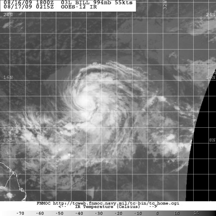
Bill Looking Better 0215Z 08.17.09

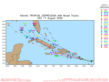
Finding Ana is like Finding Waldo 145Z 08.17.09
I would still qualify the tropics getting active by saying sorta active. When I explain you will understand. We do have 3 tropical cyclones…again sorta. The oldest of the three is Ana which was down graded to tropical depression status after a hurricane hunter went out and had a tough time finding a closed circulation and found no evidence of tropical storm force winds. The strongest winds were well north of the region suspected of being the center. If you saw yesterday’s satellite photo then you know that even then Ana looked pretty pitiful and now its even worse. In the 5pm discussion, the boys at the NHC talked about the potential of discontinuing advisories. At 11pm EDT the pressure was pegged at 1008 mb but, as I mentioned yesterday, it just doesn’t have any upper level support to help it develop, partly because its moving so fast. At a forward speed of 25 mph its tough to have time to allow an anticylone to develop aloft. But, this is the reason that this guy will be monitored, even if they discontinue the advisories…which will probably happen when they get surface reports from some of the islands showing that the storm has no circulation to speak of.
The forecast track leaves open the possibility that this guy skirts just south of Dominica and sneaks south of Cuba before crossing the western end of the island into the Gulf of Mexico. If it can maintain any sense of low level circulation as it makes that trek and its possible given its forward speed and the fact that western Cuba is relatively flat, then perhaps the environment may change and allow for upper level support to get going. That would be unusual but not impossible. So, for now, Ana looks pretty worthless but regardless of the classification, I suspect that it will still warrant a looksee in the days to come. All of that is a big if because the National Hurricane Center shifted the official forecast track in such a way as to make Ana run over the heart of the islands, which would make it almost impossible for any further life expectancy.
The cyclone known as Bill will probably become Hurricane Bill in short order. It behaved itself and moved slow enough to allow for upper level support to get established. So, it’s going to have lots of time to get wound up. It may even jump up to about 110-120 mph. But, in about 3 days, it will start to be influenced with a northerly component. A frontal system will be coming across the US. Should pass through Louisville on Thursday night. As that front comes across the nation, the ridge that extends from the Atlantic into the Eastern US will break down which will allow the storm to start to turn. As it turns and runs into some southwesterly winds aloft, then that may start to mess up its anticyclone aloft which will at least have the potential to cut off any strengthening. If the southwesterly sheer is sufficient, it may even cause it to weaken a bit. By the time we’re at Friday, the frontal trof is sitting along the east coast of the US, effectively blocking any advance of Bill toward the US and keeping it out to sea. At this time, Bill looks to be a headache for shipping and maybe for Bermuda. It would seem that the only scenario to change this outlook would be if the ridge didn’t break down so fast and the front got held up, but there is no indication of that occuring.

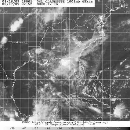
Cluster of Storms known as Claudette 0215Z 08.17.09
Now, that leads us with Tropical Storm Claudette, which formed off the Florida Panhandle. Its too close to land to really have a chance to develop rapidly. Sunday afternoon the hurricane hunters found a central pressure of just 1008 mb but they did find surface winds gusting over 50 mph. It seems to be a pretty broad center of circulation and again, the pressure isn’t too terribly low. The probability of it becoming a hurricane was pegged at 2%, but I doubt it will ever be anything more than it is on Sunday night. It should be moving ashore somewhere around Destin or just east of Pensacola. This will generally just be a rain maker. At 10:06 EDT I found a station near Panama City with winds of 22 kts gusting to 41 kts. That was the most impressive reading that I could find in the region. Offshore, seas were 7.5 feet at their highest fairly close to the center with readings closer to shore of 3-4 feet. Now, the center is shown on the official forecast track to be in Northern Mississippi by late Monday night. The models though either are not aware of the feature and so they are not initiating well, or it rains itself out along the coast because neither the NAM or GFS are too enthused about rain potential inland. However, it will be adding to atmospheric moisture at least and enhance rain chances in the Tennessee and Ohio River Valley for Monday through Thursday with the approach of the cold front and with a few shortwaves coming through the flow from the southwest ahead of the approaching trof. Really, some of the models are getting pretty aggressive with rain in the upper Ohio Valley…maybe as far south as Louisville for late Thursday.
WTNT42 KNHC 170250
TCDAT2
TROPICAL DEPRESSION ANA DISCUSSION NUMBER 20
NWS TPC/NATIONAL HURRICANE CENTER MIAMI FL AL022009
1100 PM AST SUN AUG 16 2009
RADAR IMAGERY FROM GUADELOUPE SUGGESTS THAT THE LOW-LEVEL CENTER OF
ANA HAS TURNED TOWARD THE WEST-NORTHWEST AND IS MOVING QUICKLY AT
AN INITIAL MOTION OF 285/23. ALTHOUGH SOME DEEP CONVECTION HAS
RECENTLY RE-DEVELOPED…IT IS ORIENTED LINEARLY ALONG A NORTH-SOUTH
AXIS AND APPEARS MORE REPRESENTATIVE OF A TROPICAL WAVE. THE CENTER
APPEARS REASONABLY WELL-DEFINED ON THE GUADELOUPE RADAR BUT THIS IS
LIKELY DEPICTING A MID-LEVEL CIRCULATION RATHER THAN ONE AT THE
SURFACE. AT THIS TIME WE WOULD RATHER NOT STOP ADVISORIES WHILE
THE SYSTEM IS MOVING ACROSS THE LESSER ANTILLES. HOWEVER IF
SURFACE OBSERVATIONS FROM THOSE ISLANDS CONFIRM THE LACK OF A
CENTER…ADVISORIES WILL BE TERMINATED EARLY MONDAY.
VERY FEW OF THE DYNAMICAL MODELS SHOW ANY RE-STRENGTHENING…AND A
FEW SUCH AS THE GFS…HWRF…AND GFDL LOSE THE VORTEX AFTER ABOUT
36 HOURS. THE TRACK GUIDANCE INDICATES THAT ANA SHOULD BE MOVING
OVER THE HIGH TERRAIN OF HISPANIOLA IN 24-36 HOURS…AND IT IS
DOUBTFUL THAT ITS CIRCULATION WILL MAKE IT ACROSS THAT ISLAND
INTACT. THE OFFICIAL FORECAST SHOWS ANA BECOMING A REMNANT LOW BY
36 HOURS AFTER IT BEGINS CROSSING LAND…BUT IT IS POSSIBLE THAT IT
COULD BECOME AN OPEN WAVE AT ANY TIME. THE TRACK FORECAST IS
SHIFTED NORTH OF THE PREVIOUS FORECAST TOWARD THE SHALLOW LAYER BAM
TRACK AND IN LINE WITH THE GFS AND ECMWF SINCE IT IS ASSUMED THAT
THE REMNANT CIRCULATION WILL BE STEERED BY THE LOW-LEVEL FLOW.
TROPICAL STORM WATCHES WILL REMAIN IN EFFECT UNTIL IT IS CLEAR THAT
ANA WILL NOT RE-STRENGTHEN OR UNTIL IT PASSES THE LEEWARD ISLANDS
LATER TONIGHT.
FORECAST POSITIONS AND MAX WINDS
INITIAL 17/0300Z 16.0N 61.2W 30 KT
12HR VT 17/1200Z 16.7N 64.4W 30 KT
24HR VT 18/0000Z 18.1N 68.6W 30 KT
36HR VT 18/1200Z 19.6N 72.6W 25 KT…REMNANT LOW
48HR VT 19/0000Z 21.2N 76.0W 25 KT…REMNANT LOW
72HR VT 20/0000Z 24.0N 81.0W 25 KT…REMNANT LOW
96HR VT 21/0000Z 26.0N 84.0W 25 KT…REMNANT LOW
120HR VT 22/0000Z 28.0N 86.0W 25 KT…REMNANT LOW
$$
FORECASTER BERG
WTNT43 KNHC 170253
TCDAT3
TROPICAL STORM BILL DISCUSSION NUMBER 7
NWS TPC/NATIONAL HURRICANE CENTER MIAMI FL AL032009
1100 PM AST SUN AUG 16 2009
INFRARED SATELLITE IMAGERY REVEALS AN IMPRESSIVE MASS OF DEEP
CONVECTIVE TOPS TO -80C WITHIN A CENTRAL DENSE OVERCAST…ALONG
WITH AN EXPANDING UPPER-LEVEL OUTFLOW. A LONG…WELL-DEFINED BAND
CONNECTED TO THE ITCZ IS NOTED IN THE SOUTHERN SEMICIRCLE…WHILE
LESSER BANDING COILS AROUND THE NORTHERN HALF OF THE CIRCULATION.
DVORAK T-NUMBERS ARE 3.5 AND 4.0 FROM SAB AND TAFB…RESPECTIVELY.
TAKING THE MEAN OF THESE INTENSITY ESTIMATES…THE ADVISORY WIND
SPEED IS SET AT 60 KT.
RECENT SATELLITE CENTER FIXES ARE SOMEWHAT UNCERTAIN BUT YIELD AN
INITIAL MOTION ESTIMATE OF 290/17…REPRESENTING A SLIGHTLY FASTER
FORWARD SPEED THAN BEFORE. UNDER THE INFLUENCE OF SUBTROPICAL
RIDGING TO THE NORTH…BILL IS EXPECTED TO MAINTAIN A GENERAL
WEST-NORTHWEST HEADING FOR THE NEXT 48-72 HOURS. WITH LITTLE
SPREAD IN THE CURRENT MODEL CYCLE THROUGH THIS TIME…THE OFFICIAL
TRACK DEVIATES LITTLE FROM THE PREVIOUS ADVISORY. THEREAFTER…
MODEL GUIDANCE IS IN GOOD AGREEMENT THAT A RATHER SUBSTANTIAL BREAK
IN THE SUBTROPICAL RIDGE SHOULD DEVELOP ROUGHLY ALONG 60W…WHICH
SHOULD RESULT IN A MORE NORTHWESTWARD COURSE. MOST OF THE MODEL
SOLUTIONS HAVE SHIFTED FARTHER NORTH FROM THE PREVIOUS RUNS…AND
SO HAS THE MODEL CONSENSUS. ONLY THE UKMET FAVORS A MORE
WEST-NORTHWESTWARD PATH AND APPEARS AS THE LONE…SOUTHERN OUTLIER
AMONGST THE REMAINDER OF THE GLOBAL MODELS. THE OFFICIAL FORECAST
IS ADJUSTED NORTH OF THE PREVIOUS ONE…ESPECIALLY BEYOND 96
HOURS…BASED ON THE LATEST GUIDANCE.
EVEN THOUGH ENVIRONMENTAL SHEAR IS QUITE LOW…BILL HAS BEEN
TRACKING OVER MARGINAL SEA SURFACE TEMPERATURES AND WATERS ARE NOT
FORECAST TO WARM FURTHER UNTIL AFTER 24 HOURS. INTERESTINGLY…THE
GFDL/HWRF SHOW A NEARLY FLAT INTENSIFICATION RATE FOR THE NEXT DAY
OR TWO…PERHAPS UNDERSCORING THE TEPID THERMODYNAMIC CONDITIONS. IT
SHOULD BE NOTED…HOWEVER…THAT THE SHIPS RAPID INTENSITY INDEX
SHOWS A 41% CHANCE OF A 30 KT INTENSITY INCREASE DURING THE NEXT 24
HOURS. THEREAFTER…THE GUIDANCE IS IN GOOD AGREEMENT THAT LOW
SHEAR AND WARMING WATERS SHOULD PREVAIL FOR BILL…ALLOWING THE
CYCLONE TO EVOLVE INTO A MAJOR HURRICANE OVER THE FORECAST PERIOD.
THE OFFICIAL FORECAST IS CLOSEST TO THE SHIPS MODEL GUIDANCE…
WHICH PREDICTS A FAIRLY STEADY RATE OF DEVELOPMENT OVER THE NEXT
FEW DAYS. TOWARD THE END OF THE FORECAST PERIOD…THE GLOBAL
MODELS HAVE BEEN HINTING AT INCREASING WESTERLY SHEAR AS BILL
OUTRUNS FAVORABLE ANTICYCLONIC FLOW TO THE SOUTHEAST.
ACCORDINGLY…THE OFFICIAL INTENSITY FORECAST SHOWS SLIGHT
WEAKENING NEAR THE END OF THE PERIOD.
FORECAST POSITIONS AND MAX WINDS
INITIAL 17/0300Z 13.4N 41.7W 60 KT
12HR VT 17/1200Z 14.1N 43.7W 70 KT
24HR VT 18/0000Z 14.9N 46.5W 80 KT
36HR VT 18/1200Z 15.8N 49.2W 85 KT
48HR VT 19/0000Z 16.8N 51.8W 95 KT
72HR VT 20/0000Z 19.7N 56.8W 105 KT
96HR VT 21/0000Z 23.5N 61.5W 105 KT
120HR VT 22/0000Z 28.1N 65.5W 100 KT
$$
FORECASTER KIMBERLAIN/PASCH
WTNT44 KNHC 170247
TCDAT4
TROPICAL STORM CLAUDETTE DISCUSSION NUMBER 5
NWS TPC/NATIONAL HURRICANE CENTER MIAMI FL AL042009
1000 PM CDT SUN AUG 16 2009
CLAUDETTE HAS NOT BECOME BETTER-ORGANIZED OVER THE PAST SEVERAL
HOURS. DOPPLER RADAR VELOCITIES STILL SUPPORT AN INTENSITY OF
40-45 KT SO THE ADVISORY INTENSITY REMAINS AT 45 KT. MODERATE
WEST-SOUTHWESTERLY SHEAR HAS BEEN IMPINGING ON THE STORM…AND
APPARENTLY PREVENTING THE CYCLONE FROM STRENGTHENING.
HOWEVER…RADAR AND SATELLITE IMAGERY INDICATE THAT THE SYSTEM
CONTINUES TO GENERATE SOME STRONG CONVECTION MAINLY OVER THE
EASTERN SEMICIRCLE OF THE CIRCULATION…AND IT IS IN THESE
CONVECTIVE REGIONS WHERE TROPICAL STORM FORCE WINDS ARE LIKELY
OCCURRING AT THE SURFACE. WITH LANDFALL NOW IMMINENT…THE WINDOW
OF OPPORTUNITY FOR CLAUDETTE TO STRENGTHEN IS QUICKLY CLOSING.
THE CENTER WOBBLED A LITTLE TO THE WEST A FEW HOURS AGO BUT NOW IS
MORE OR LESS BACK ON TRACK…ALBEIT AT A SLIGHTLY SLOWER FORWARD
SPEED. INITIAL MOTION IS ABOUT 315/10. THE TRACK FORECAST AND
REASONING ARE ESSENTIALLY UNCHANGED. THE TROPICAL CYCLONE SHOULD
CONTINUE TO MOVE AROUND THE WESTERN PERIPHERY OF A MID-LEVEL HIGH
PRESSURE AREA UNTIL DISSIPATION OVER THE SOUTHEASTERN UNITED
STATES. THIS OFFICIAL FORECAST IS BASICALLY AN UPDATE OF THE
PREVIOUS ONE.
THE MAIN CONCERN WITH THIS SYSTEM IS LOCALLY HEAVY RAINFALL AND
INLAND FLOODING. PLEASE REFER TO STATEMENTS…WATCHES…AND
WARNINGS FROM LOCAL NATIONAL WEATHER SERVICE FORECAST OFFICES.
FORECAST POSITIONS AND MAX WINDS
INITIAL 17/0300Z 30.2N 86.1W 45 KT
12HR VT 17/1200Z 31.3N 87.2W 40 KT…INLAND
24HR VT 18/0000Z 33.0N 88.3W 30 KT…INLAND
36HR VT 18/1200Z 35.0N 88.9W 20 KT…DISSIPATING INLAND
48HR VT 19/0000Z…DISSIPATED
$$
FORECASTER PASCH


