

Tornado Threat
The big MCS in Iowa and Illinois came down as expected overnight but faded as it

Hail Threat
moved into our region. Look for subsidence in its wake to inhibit storm development for much of the day. Late in the day, we heat up very nicely, reload and wait for the next wave along the front. That will elevate the prospects for thunderstorms and the potential for more strong storms. Probably a better shot than the overnight. We’re still on track for a nice couple of days after today.
For an interactive radar that allows you to track storms down to street level from
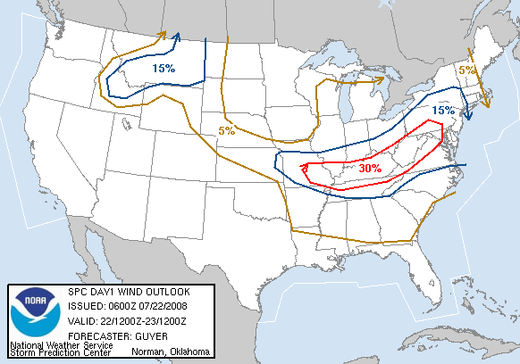
Wind Threat
any part of the country so you can see where they are as they develop west of the viewing area, Click Here. For updates on watches or warnings for our area throughout the day, Click Here. In both cases, simply click the icon pick for what you want, which also has a local live radar.
SEE 5 PM TUESDAY JULY 22 UPDATE FOR HURRICANE DOLLY HERE. YOU WILL FIND LATEST TRACK AS WELL AS LINK TO RADAR LOOP


 A couple of things to note about Dolly. First off, with the recent movement due west, the models have come into a closer agreement about the landfall near Brownsville. I like the one that holds it in tact across the Chihuahua Desert all the way to the other side of Baja California and about 70 degree water in the southern reaches of the California Stream. Anyway, the only fly in the ointment would be a bunch of short waves moving through the midwest that should erode the steering ridge a bit that could allow it to move farther north than the forecast. If you note at the bottom of the discussion there is the reference to not relying on exact landfall location and such. They seem to be announcing that more forcefully with this storm. Also, in spite of what you may have heard on national TV, there is still some shearing going on with an upper low in the Bay of Campeche that the satellite clearly shows is impeding the outflow of the southeastern part of the storm. That is progged to move out and so the outflow should become more consistent. The internal structure is getting better and so it should strengthen and they do take it to hurricane status prior to landfall. The question here is whether or not it slows down enough to allow it to get going to its potential which would otherwise be pretty good if it weren’t going to probably run out of Gulf of Mexico to work with. The oil rigs in the Gulf shouldn’t be adversely affected too much as long as the storm behaves itself and goes where it is supposed to.
